Where is Guatemala on the map
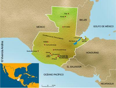
Image: Andean Experience
Located in the extreme north-west of Central America, in the cultural region of Mesoamerica, it is found Guatemala. Its capital is Guatemala City, with just over 2 million inhabitants, being the city with the most inhabitants in the country. In this lesson from unPROFESOR.com we are going to find out where is Guatemala on the map to get to know this wonderful country better.
Index
- Guatemala, a country in Central America
- Geography of Guatemala
- The origin of Guatemala
- Curiosities of Guatemala
Guatemala, a country in Central America.
Guatemala is a sovereign state located in the extreme northwestern part of Central America. Guatemala is the country with the most inhabitants in this region, and the tenth country with the most inhabitants in all of America, with a total of 16,896,000 inhabitants. It has an area of 108,889 km2, so it has a density of 152.6 inhabitants per km2.
To know where Guatemala is on the map we have to place its position compared to other countries. Guatemala borders several countries and the sea. To the north and west it borders Mexico, to the east with Belize, the Gulf of Honduras and Honduras, to the south with the Pacific Ocean, and southeast with El Salvador.
Guatemala is located in Mesoamerica. A cultural region that includes the territories of Guatemala, El Salvador, Belize and also part of Mexico, El Salvador, Nicaragua and Costa Rica. It is a region in which all the inhabitants have similar cultural traits, because they all start from similar indigenous roots.
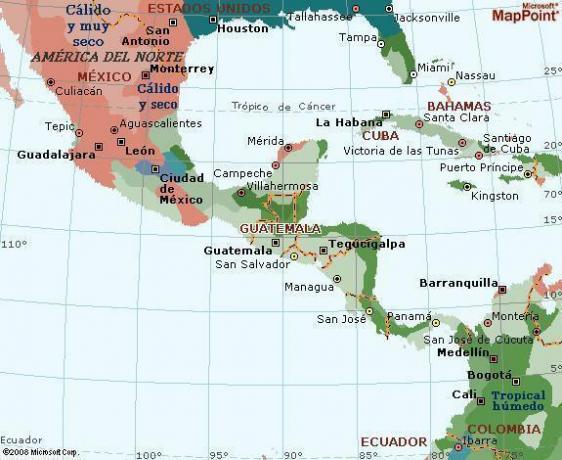
Image: voyagesphotosmanu.com
Geography of Guatemala.
Guatemala is a largely mountainous country. It is crossed by the Cordillera de los Cuchumatanes and the Sierra Madre del Sur. Although it also has a part of the sea, with soft beaches in the area that borders the Pacific Ocean.
Because of the mountain ranges the country is divided into three parts:
- The high side, with the biggest mountains
- The Pacific Coast, where we can find the aforementioned beaches
- And the area of Petén
Guatemala is a zone with 37 volcanoes, of which 4 are in an active situation. Due to the presence of these volcanoes, earthquakes are common in the country. One of these volcanoes is the Tajumulco, which at 4220 meters is the highest point in the country, and in all of Central America.
That Guatemala is a country with so many contrasts makes there a great climatic differentiation depending on the area of the country. There is a warm climate in the Pacific zone and in the Petén zone, the first being a more humid climate and the second a drier climate. And on the other hand, a cold or arid climate in the upper zone, depending on which part of the higher zones we talk about.
The origin of Guatemala.
Continuing with the lesson of where Guatemala is on the map, we must talk about their history, to understand the culture of this country.
The origins of Guatemala can be found in the Mesoamerican cultures that inhabited the region until the arrival of the European colonizers. The predominant culture was the Mayan culture, a civilization advanced in its time, which inhabited what is now Guatemala for almost two thousand years.
But the Mayans were not the only ones who occupied the land of Guatemala. The existence of cakchiqueles, mam, quiché, tzutujiles and the kek'chi. These peoples still exist today in Guatemala and other parts of America.
In 1553 the Spanish conquerors arrived in Guatemala, from their territories on Mexican soil. In 1541 King Carlos V gave the titles of Governor of Guatemala to the conqueror Pedro de Alvarado. Guatemala therefore became part of the colonial territories of Spain, being a general captaincy dependent on the Viceroyalty of New Spain.
Guatemala was part of the domains of the Spanish crown until 1821, at which time it became independent along with other territories in present-day Central America. These territories formed the Federal Republic of Central America, which lasted from 1824 to 1839. After some conflicts with other Central American countries, Guatemala ended up becoming independent, thus creating the Republic of Guatemala.
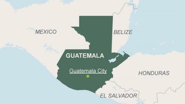
Image: KfW Entwicklungsbank
Curiosities of Guatemala.
- Although the official language of Guatemala is Spanish, there are other 21 languages in the country. They are indigenous languages supported by different institutions so that they do not disappear.
- The farming It is an important part of the country's economy, contributing up to a quarter of the gross domestic product. Some of its most popular products are sugar or banana.
- The name of Guatemala means "land of trees”In one of the indigenous languages. Something important since Guatemala is recognized for its great biodiversity, and the importance of its flora.
If you want to read more articles similar to Where is Guatemala on the map, we recommend that you enter our category of Geography.