Complete LIST with the RIVERS of Guatemala

One of the physical elements of the countries and that we least usually take into account are the rivers, these being very important for the economic situation of the state, and as a general rule vital in the origins of the country. To know the rivers of one of the main Central American States in this lesson from a PROFESSOR we are going to talk about the rivers of Guatemala with map.
Index
- What is Guatemala?
- Rivers of Guatemala on the Atlantic slope
- Rivers of Guatemala on the Pacific slope
What is Guatemala?
Before talking about the rivers of Guatemala we must define even briefly the Central American country, to better understand the importance of these aquatic areas for the region.
Guatemala is a state located in America, more specifically in the central area of the continent, being a small country whose cultural origins are born of the Mayans and the Spanish influence after the conquest of America by the colonizers. Regarding its situation, we must comment on its limits, being its border to the west and north with Mexico, to the east with Belize, Honduras and the Gulf of Honduras, and to the south with the Pacific Ocean.
Guatemala is a small state, compared to other large countries in North and South America, but it is still a great country compared to the other Central American states. Even with its small size, it is still a state with a very interesting geography, with great variety of rivers and with many climate changes depending on the area, largely due to its interesting variety of altitudes due to the mountains.
The great importance of Guatemala is that it is the state with the largest number of inhabitants of Central America, with more than 17 million inhabitants, also having the most populated city in the subcontinent, this being Guatemala City. Of these 17 million inhabitants, almost a third are from indigenous origin, so we can see the great importance of the culture of the ancient peoples for this Central American country.

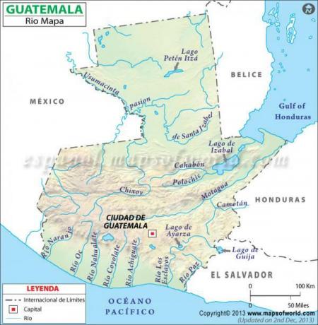
Image: World Map - World Map
Rivers of Guatemala on the Atlantic slope.
When speaking of the rivers of Guatemala we can speak of two main classes, those that flow into the Atlantic slope and those that flow into the Pacific slope. In the case of the Atlantic slope, we can comment on two types of rivers, those that flow into the Gulf of Mexico and those that do. in the Gulf of Honduras, the first being generally tributaries of the great Usumacinta, and the second great deep rivers and navigable. To better understand this slope, we must now comment on some of the main rivers of the Atlantic slope.
Usumacinta River
The Usumacinta is a river that has its source in the Sierra Madre in Guatemala and flows into the Gulf of Mexico. It is the longest and mightiest river in all of Central America, being vital to the geography of Guatemala due to the large number of tributaries it has in the area. The length of the river is 1100 kilometers, while the extension of its basin is more than 100,000 km2.
Chixoy River
Also called Rio Negro it is the third longest river in Guatemala with a length of 530 kilometers, and a basin with an extension of 12,000 km2. As for its source, we can find it in Quiché, from where it runs until it empties into the Salinas River.
Motagua River
The Motagua is a river that rises in the Quiché and flows into the Caribbean Sea. Its length is about 486 kilometers, while the extension of its hydrographic basin is 12,670 km2.
Sweet River
The Dulce River is a Guatemalan river that has its source in Lake Izabal and flows into Amatique Bay after a journey of 43 kilometers.
Deep River
The Hondo is a river that is born by the union of the Azul and Bravo rivers, crossing Guatemala, Belize and Mexico before flowing into the Chetumal Bay. The length of the Hondo is about 209 kilometers, while the extension of its basin is 13,500 km2.

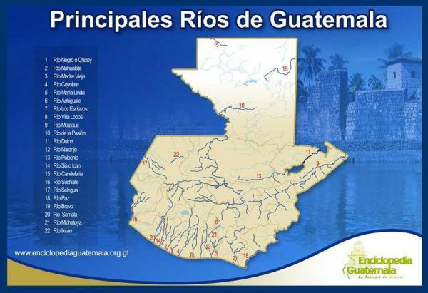
Image: Encyclopedia Guatemala
Rivers of Guatemala on the Pacific slope.
To conclude this lesson on the rivers of Guatemala with a map we must comment on the main rivers Guatemalans on the Pacific slope, all of them being small rivers, although with great importance in area.
Samalá River
The Samalá is a river that originates in the departments of Totonicapán and Quetzaltenango and flows into the Pacific Ocean. Like all rivers on this slope, it has a short length of about 145 km, while the extension of its basin is 1510 km2.
Suchiate River
The Suchiate is born in the San Marcos area, more specifically in the area of the Tacaná volcano, while its mouth is in the Pacific. The extension of the Suchiate is 161 kilometers, while the extension of its basin is 1400 km2.
Naranjo River
The Naranjo is born in the Sierra Madre and empties into the Pacific after a movement towards the south. Its length is very short, being only 105 km, while the extension of its basin is about 1273 km2.
Ocosito River
Like many of the rivers of the Pacific, the Ocosito has its source in the Sierra Madre and flows into the Pacific. Regarding its length, it is little more than 100 kilometers, while the extension of its basin is 2000 km2.
If you want to read more articles similar to Rivers of Guatemala with map, we recommend that you enter our category of Geography.


