
List with ALL the rivers of Mexico
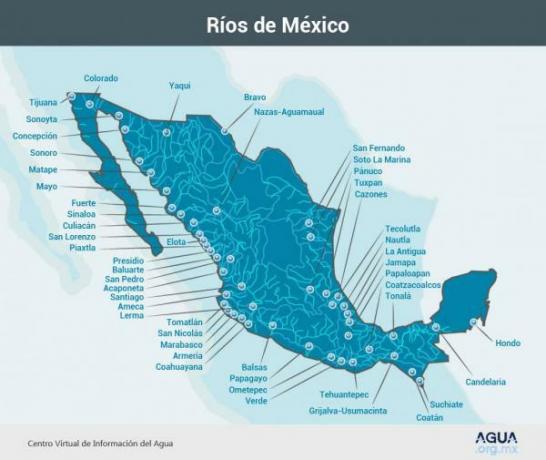
Image: Agua.org.mx
One of the most important natural elements are rivers, which greatly change the landscape of a country. In the case of Mexico rivers occupy a large part of its geography, since there are endless streams throughout the territory. Of all these rivers there are 51 that are called main, since they occupy most of the water of the Central American state. To know these 51 currents in this lesson from a TEACHER we are going to talk about the rivers of Mexico with map.
Index
- Rivers of Mexico on the western or Pacific slopes
- Rivers of Mexico on the eastern or Atlantic slopes
- Rivers of Mexico from the southern slope
Rivers of Mexico on the western or Pacific slopes.
There are three divisions when we talk about the Mexican rivers, depending on the area through which they flow. The first of these divisions is the so-called western slope, being that formed by the rivers that flow into the Pacific Ocean.
The western Mexican rivers are characterized by being some of those of
largest size in the whole countryAs a general rule, most of the rivers in the area are short and not very large.To talk about the western slope we must comment on the rivers that make up the area, giving greater importance to those that for various reasons are better known or of greater relevance to the inhabitants of the country Mexican.
Rio Grande de Santiago
It is an important river in the western part of Mexico, which is born in Ocotlán and empties into the Pacific Ocean. It is one of the rivers that contributes the greatest amount of water, passing through up to 6 Mexican states. Some people consider it to be the continuation of the Lerma River, which would make it the second longest in all of Mexico.
Balsas River
Located in the south-central zone of Mexico, it passes through Guerrero and Michoacán before reaching its mouth in the Pacific Ocean. It is one of the longest rivers in the country, and among its characteristics is that its valley was possibly one of the first places where corn was grown, and which is a great source of hydroelectric power.
Rivers Sonora, Fuerte, Mayo and Yaqui
These rivers are the most relevant in the northwestern part of the Mexican country. They are great protagonists in the country's agriculture, since without their existence the important crops of the Mexican northwest would not exist.
Colorado River
El Colorado is located in northwestern Mexico and southwestern United States. It is one of the longest rivers in all of North America, passing through several Mexican and American states to its mouth in the Pacific Ocean. One of the reasons that the Colorado is so famous is that it is the cause of the formation of the Grand Canyon of the Colorado.
Other rivers on the western slope
Having discussed the main rivers that flow into the Pacific Ocean, we must talk about the rest of those that are part of the western slope. These rivers are the following:
- Tijuana.
- Sonoyta.
- Conception.
- Green.
- Ometepec.
- Parrot.
- Saint Peter.
- Culiacan.
- Ameca.
- Sinaloa.
- Armory.
- Coahuayana.
- Bulwark.
- San Lorenzo.
- Suchiate.
- Acaponeta.
- Piaxtla.
- Presidio.
- Tomatlán.
- Tehuantepec.
- Coatán.
- Marabasco.
- St nicolas.
- Huicicila.
- Elota.
- Matape.
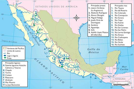
Image: Agua.org.mx
Rivers of Mexico on the eastern or Atlantic slopes.
The eastern slope is the one formed by all those rivers that flow into the Caribbean Sea or the Gulf of Mexico. As in the previous section, we must also comment on some information about the most important rivers on the slope.
Bravo River
Also called Rio Grande, is a river located north of Mexico and the south of the United States. It is born in the San Juan Mountains in Colorado and empties into the Gulf of Mexico, being the third longest North American river.
Usumacinta River
It is a river whose source takes place in the Sierra Madre and its outcome at the mouth of the Gulf of Mexico. It is the largest river in all of Central America, and also the longest in this region. It was a very important river for the Mayans, with other important Mayan cities that used the river for trade on its shore.
Grijalva River
It is the union of several rivers in the southeast of Mexico, forming the second largest river and the one that generates the most hydroelectric energy in the Mexican state. Its source takes place in the Écija Valley in Guatemala, and its mouth occurs in the Gulf of Mexico.
Pánuco River
This river is born in the Mexican Central Table and empties into the Gulf of Mexico. It is one of the largest rivers in Mexico, and also one of the most polluted by human misuse.
Other rivers on the eastern slope
Having discussed the main rivers that flow into the Gulf of Mexico, we must talk about the rest that are part of the eastern slope, being a smaller number than those of the slope western. These rivers are the following:
- Papaloapan.
- Coatzacoalcos.
- Tonalá.
- Tecolutla.
- Nautla.
- The old one.
- Soto La Marina.
- Jamapa.
- Candelaria.
- Tuxpan.
- Deep.
- Cazones.
- San Fernando.
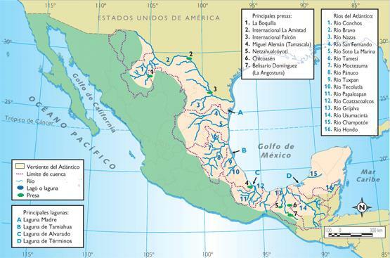
Image: Agua.org.mx
Rivers of Mexico on the southern slope.
To conclude this lesson on rivers of Mexico with map, we must talk about the so-called southern slopes rivers, being all those that they do not flow into a sea, but ends up in an interior zone. The main inland rivers of Mexico are the following:
Nazas River
It is an inland river in the northern part of Mexico, passing through the states of Durango and Coahuila. It is currently in danger, due to the overexploitation it has suffered for agricultural production. It is mainly important because thanks to it there is the most important dairy area in the Mexican state.
Aguanaval River
This river is born by the union of several streams of the Sierra de Zacatecas. Its main use is agricultural, and its waters are used in the La Laguna region for this type of production.
Lerma River
The longest inland Mexican river, being born in the springs of Almoloya del Río and ending in Lake Chapala. Some people consider that it is attached to the Rio Grande, which would make it the second longest river in all of Mexico.
If you want to read more articles similar to Rivers of Mexico - with map, we recommend that you enter our category of Geography.